Home
A77 Active Corridor - Phase 3
Background
East Renfrewshire Council is working to deliver major improvements for active travel (walking, wheeling, and cycling) along Ayr Road as part of the A77 Active Corridor project.
Previous phases of work have significantly upgraded the foot and cycle paths along the rural section of Ayr Road (Phase 1) and in the Malletsheugh/Maidenhill area of Newton Mearns (Phase 2).
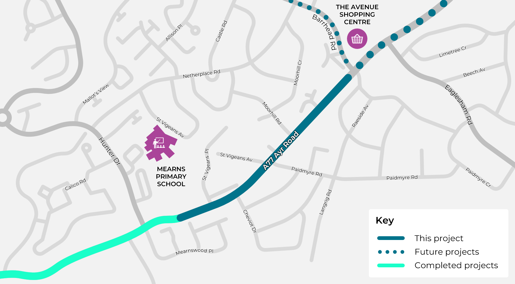
We are pleased to announce that the next phase of the project is now being developed. Phase 3 will extend the route further along Ayr Road - from Hunter Drive to Barrhead Road - as shown on the map below. Once complete, there will be a continuous and attractive active travel route between Maidenhill and Newton Mearns town centre.
Project Aims
The project has the following key aims:
- Enable more people to choose active travel for short local trips and for recreation by upgrading the footways to the latest accessibility standards and building new cycleways that are separated from the road.
- Improve convenience for residents and tackle current parking problems by creating new on-street parking bays at several points along Ayr Road. This will provide places for visitors and delivery drivers to park without blocking the footways or cycleways.
- Make Ayr Road safer for everyone by reallocating road space, encouraging driving at lower speeds that are more appropriate for a place where people live.
Progress So Far
In late 2023, we appointed the engineering consultancy firm Sweco to develop Concept Design and Detailed Design plans for the new route. The Concept Design plans are now complete - please see the information below to learn more about these plans and how they might affect you.
Please note that we will soon be consulting separately on plans to extend the A77 Active Corridor from Newton Mearns town centre towards Glasgow. Keep an eye on this website over the next few weeks to find out how to take part in those activities.
When the Detailed Design plans are completed in Spring 2024, we will seek opportunities to apply for external grants to fully fund construction work. In the past, projects to improve active travel on Ayr Road have been funded by SPT, Sustrans, and Transport Scotland.
If successful, we would then run a competitive tendering exercise to select a suitable contractor. It is likely that this would take several months, with construction itself then taking a further 6-12 months.
Walking and Wheeling
The project aims to make Ayr Road more accessible and provide clear priority for people walking and wheeling. This will be achieved by improving the pedestrian crossing facilities and traffic calming measures, as described below.
Crossing Facilities
The existing traffic light controlled crossing near Paidmyre Road will be retained in its current location. We also plan to provide a series of 'informal' crossing points along Ayr Road. These will not include traffic lights, or any other form of pedestrian priority: they will simply highlight recommended crossing locations, for example near bus stops, and will be accessible for wheelchair users.
Continuous Footways
Continuous footways provide a strong visual impression that people walking or wheeling along a main road have priority over people driving or cycling in and out of the side roads - in line with the rules of the Highway Code.
They also reduce vehicle speeds by acting as a speed bump between the main road and the side road. This will improve safety for people crossing at the junction, and help to discourage speeding in smaller residential streets.
We plan to build continuous footways at every side road junction along Ayr Road: St Vigeans Place, Cheviot Drive, St Vigeans Avenue, Paidmyre Road, Moorhill Road, and St Catherine's Gate. This will ensure a consistent design approach along the entire route.
At traditional side road junctions, the footway is interrupted by the road. This gives the impression that people walking should give way to vehicle traffic. However, the updated Highway Code Rule 170 clarifies that, when driving or cycling, you should "give way to pedestrians crossing or waiting to cross a road into which or from which you are turning".
Continuous footways support this rule by continuing the footway directly across the side road junction. It is still possible to drive across continuous footways to access the side roads - just as it is possible to drive across ordinary footways to access driveways. However, the design will make clear that priority should be given to people walking and wheeling.
Since drivers need to travel up and down a ramp to cross continuous footways, vehicle speeds in the areas around these junctions will be reduced. This will improve safety for everyone, though we would still encourage all users to look out for each other.
Continuous footways are an increasingly common way of prioritising people walking and wheeling in the UK. They are supported by national guidance, such as Transport Scotland's Cycling by Design, and are standard practice in the Netherlands, where many of the most successful methods of designing streets for active travel originate.
The following photograph shows an example of a continuous footway which has already been built a little further along Ayr Road as part of the A77 Active Corridor - Phase 2 project.

The map below shows where we are planning to make changes to junctions and crossings.

Widths and Surfaces
We consider that the footways on Ayr Road are already the right width for the number of people walking in the area, so the current concept design plans don't show any major changes to the width of the footways. It is likely that we will resurface some parts of the footways where necessary.
Accessibility
The project will significantly enhance accessibility for people using a wheelchair or mobility scooter. Due to the introduction of continuous footways, people walking or wheeling on Ayr Road will benefit from a completely level surface along the entire route. This means you will no longer need to travel up and down as many ramps when moving through the area.
There is currently limited provision of tactile paving on this part of Ayr Road. To improve accessibility for visually impaired people, we plan to provide new tactile paving at all the key locations where we think people will want to cross the road or cycleways. This will include tactile paving before and after all continuous footway areas.
Tactile paving is designed to provide information to visually impaired people. Various patterns and colours are available, each of which is intended to indicate the presence of different features in the built environment.
In line with current standards, we plan to use the following types of tactile paving in this project:
Red 'blister' tactile paving will be used in places where 'formal' pedestrian crossing facilities are provided. These include:
- The existing traffic light crossing on Ayr Road near Paidmyre Road. Tactile paving will mark the location of the crossing.
- All bus stops. Tactile paving will mark the location of the mini-zebra crossing between the footway and the bus stop waiting island.
Yellow 'blister' tactile paving will be used in places where people are likely to cross the road but no 'formal' pedestrian crossing facilities are provided. These include:
- All side road junctions (where continuous footways will be provided). Tactile paving will warn you that vehicles can cross the footway in these places.
- Various points where we think people will want to cross Ayr Road. Tactile paving will warn you that you are about to enter the road or cycleway.
Cycling
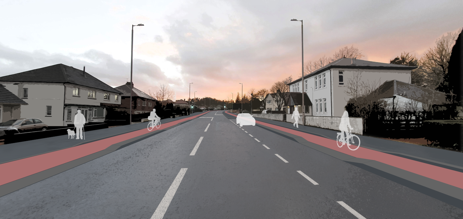
We plan to replace the existing painted cycle lanes on Ayr Road with new cycleways that are physically separated from the footways and the road. This will make cycling safer and more comfortable for a wider range of people - especially those who are currently put off by the idea of cycling on the road. We have also kept people who already cycle in mind by ensuring the cycleways will be wide enough for everyone.
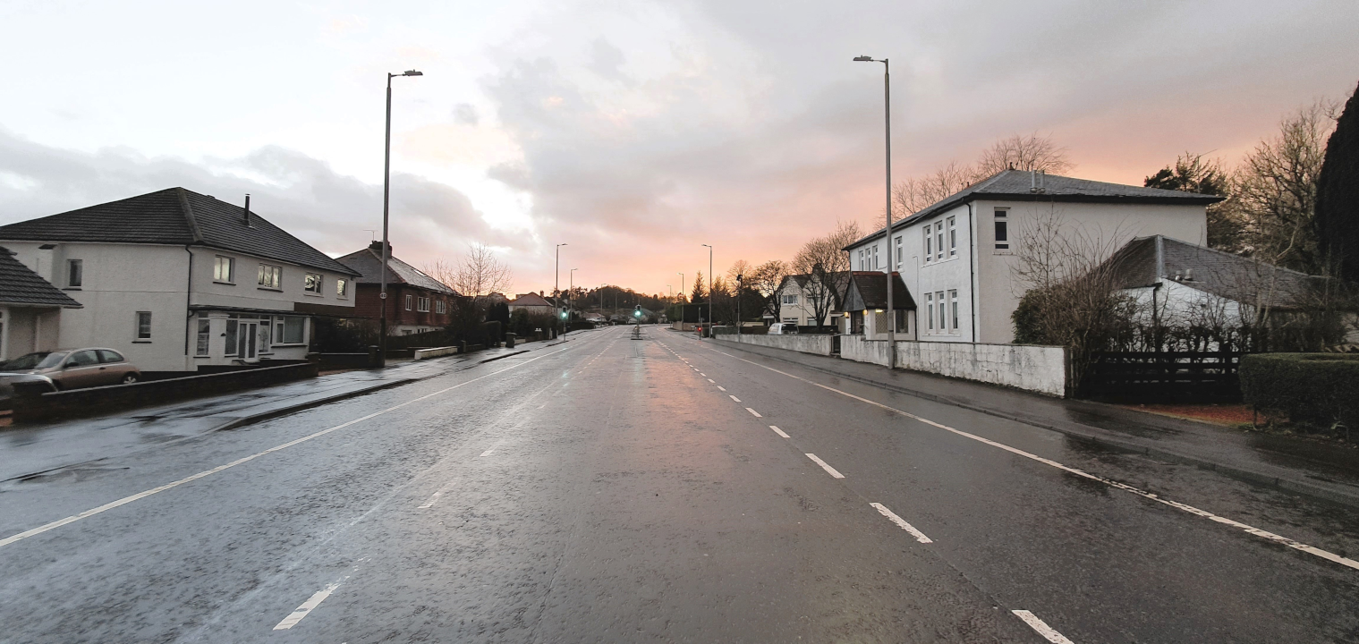
The 'before and after' slider below shows an example of what the new cycleways will mean for the overall layout of the road.
Widths and Surfaces
While the existing cycle lanes are 2.0m wide, the new cycleways will generally vary from 2.0m to 2.5m wide in each direction. The extra space will make it easier for you to cycle side-by-side with a friend, or overtake another cyclist. All widths will be in compliance with the recommendations set out in in Transport Scotland's Cycling by Design guidance.
It is likely that the cycleways will have a colour contrast to distinguish them from the road and the footways. This will provide a strong visual impression that people cycling along Ayr Road have priority over people driving in and out of the side roads. This will be further supported by appropriate signage and markings.
Buses
We plan to keep all bus stops at, or very close to, their current locations on Ayr Road. The map below shows the planned bus stop locations:

All bus stops will feature a large waiting island for people to stand on while boarding or alighting buses - often known as a 'floating bus stop'. To move between the waiting island and the footway, you will need to cross the cycleway: a raised mini-zebra crossing will be provided to make this easy for everyone and encourage cyclists to slow down.
The bus stops will be designed to be accessible for everyone. The waiting island will provide enough space to turn around if you're using a wheelchair, and there will be tactile paving to mark the location of the crossings.
At bus stops that currently have shelters, these will be renewed with new shelters.
Driving and Parking
There is currently much more road space on this part of Ayr Road than is needed for the number of vehicles using it, so we plan to remove the central reservation (the traffic island and surrounding painted area that separates vehicles travelling in opposite directions).
This will leave a simple single-carriageway road with one lane for vehicles travelling in each direction. Since the road will be a minimum of 6.4m wide (i.e. 3.2m wide in each direction), there will still be enough space for all types of vehicles including buses and HGVs.
Reallocating road space will encourage driving at lower speeds that are more appropriate for a place where people live. It will also enable us to make other positive changes on Ayr Road, such as providing separated cycleways and dedicated on-street parking bays.
We plan to provide new on-street parking bays at several points along Ayr Road. This will improve convenience for residents and reduce current problems with obstructive parking. Three dedicated parking areas will be established, as detailed in the following map and table:
| Area | Capacity | Location |
|---|---|---|
| A | 6 cars | 217 - 221 Ayr Road |
| B | 7 cars | 306 - 308 Ayr Road |
| C | 9 cars | 257 - 269 Ayr Road |
Please note that:
- The parking bays will be available for use by residents, visitors, delivery drivers, etc.
- The above figures for parking capacity allow clearance for driveway access.
- It will not be possible to provide parking along the entire length of Ayr Road. This is because we need to accommodate features like bus stops and avoid restricting visibility at junctions.
Access to all private driveways will be maintained by providing dropped kerbs to enable you to drive across the footway and cycleway.
As at present, people walking, cycling, and driving along Ayr Road will have priority - you should check the road and paths are clear before entering or exiting your driveway.
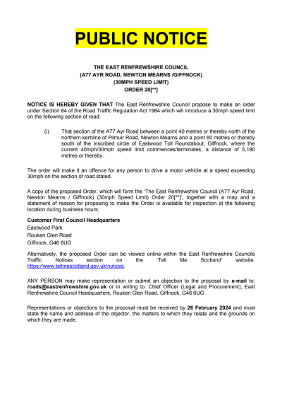
30mph Speed Limit
Plans to reduce the speed limit on Ayr Road from 40mph to 30mph are underway, with comments currently being invited.
Changing the speed limit will require a Traffic Regulation Order, a legal process with specific requirements for public consultation. For this reason, we can't consider any comments on the proposed 30mph speed limit made through this Commonplace website.
Please see the Ayr Road 30mph - Public Notice document provided below for information on how to comment on these plans.
Find out more about our 30mph plans here
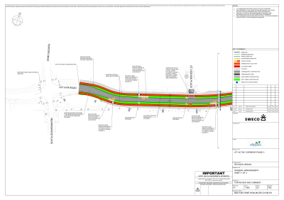
Concept Design Plans
We hope the information on this page has been useful. If you'd like to see more detail, the full Concept Design plans are provided below.
Check out the full Concept Design plans here
Have Your Say
We're keen to hear your thoughts on these plans to help us identify any issues that need to be considered as we progress towards the final Detailed Design. We invite you to complete the short survey below to let us know what you think.
Please note that the closing date for feedback to be received is Sunday 25th February 2024.
This engagement phase has finished

...